
Click on image to view full-sized photo.
Photo Description: A view of the Baldwin City Roadside Park, showing the gravel loop road, the replica log cabin, and the shaded grassy area for picnicking or camping.
Photo Date: 06-30-2012
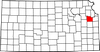
Photo Location: Baldwin City, KS
GPS Coordinates: 38.767288888889,-95.128925
Copyright: Copyright 2012 by KansasCyclist.com. All Rights Reserved.
Learn More: US-56 Baldwin City Roadside Park
See Also: More US-56 Baldwin City Roadside Park Photos

Photo Location Map