
Click on image to view full-sized photo.
Photo Description: This sign designates Old Route 66 Park to be administered by the National Park Service, and supported by the Land and Water Conservation Fund, which provides "outdoor recreation and open space for all".
Photo Date: 11-27-2012
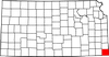
Photo Location: Baxter Springs, KS
GPS Coordinates: 37.066808,-94.726457
Copyright: Copyright 2012 by KansasCyclist.com. All Rights Reserved.
Learn More: Old Route 66 Park
See Also: More Old Route 66 Park Photos

Photo Location Map